 |
||||
|
Date: October 01, 2019 Time: 1600 PST
Press Release: More rains predicted in the country during the current week
Met Office informed that westerly wave is presently affecting upper and central parts of the country. This weather system is likely to interact with monsoon currents on Wednesday (evening/night) and it will grip most parts of the country on Thursday. Under the influence of this weather system:
Note: Heavy rains may trigger landslides in districts of Malakand, Hazara, Gilgit Baltistan and Kashmir during next 4-5 day. Farmers are particularly advised to take precautionary measures during the forecast period.
Spokesperson
Date: September 24, 2019 Time: 1700 PST Press Release: Rains/wind-thunderstorm predicted in the Country from Wednesday to Tuesday Met office informed that more monsoon currents from Bay of Bengal are likely to penetrate in northeastern and south eastern parts of the country and likely to strengthen from Thursday. A westerly wave is also expected to enter upper parts of the country from Friday. Under the influence of this weather system: Kashmir/Gilgit-Baltistan:
Punjab/Islamabad:
Khyber-Pakhtunkhwa:
Sindh:
Balochistan:
Note: Heavy falls may generate flash flooding in districts of Hazara, Malakand, Rawalpindi, Gujranwala, D.G.Khan Islamabad and Kashmir, while urban flooding in Peshawar, Rawalpindi, Gujranwala and Lahore during Saturday to Monday. Heavy falls may also generate Urban flooding in districts of Hyderabad, Thatta, Badin and Karachi on Saturday and Sunday. Possibility of landslide in districts of Malakand, Hazara, Gilgit Baltistan and Kashmir cannot be ruled out during the period. All concerned authorities are advised to remain ALERT and take precautionary measures during the forecast period.
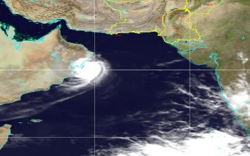
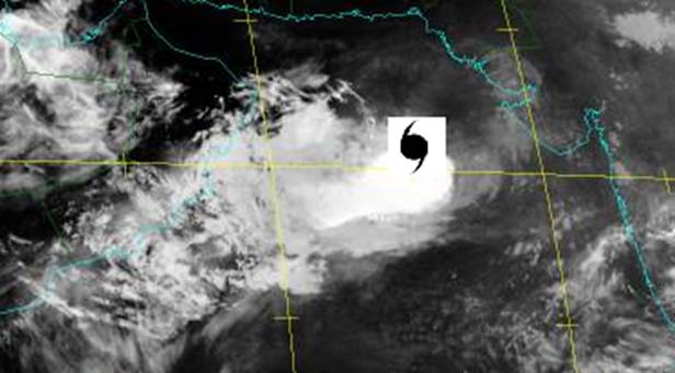
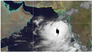
Spokesperson Date: September 24, 2019 Time: 1100 PST Press Release:- Tropical Cyclone "HIKAA" in the Arabian Sea The Severe Cyclonic Storm “HIKAA” over east central Arabian Sea has intensified into a Very Severe Cyclonic Storm and tracked westwards at a speed of 22km/hour and is now located around Lat: 20.9°N Long: 61.3°E about 880 km west-southwest of Karachi. TC “HIKAA” is likely to continue tracking westwards Oman Coast during next 12 hours and become Severe Cyclonic Storm before crossing Oman Coasts near “Duqm” late tonight. Currently none of Pakistan coastal area is under threat from this system. However, the fishermen of Balochistan are advised to remain alert and not to venture in deep sea. The authorities and stakeholders are requested to abreast themselves of updates through PMD website.
Fig. Satellite imagery at 1000 PST of today the 24th Sep: 2019
Spokesperson
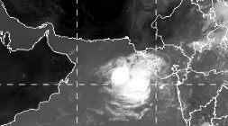
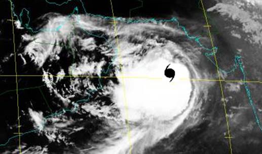
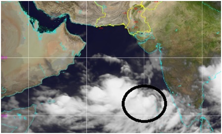
Date: September 23, 2019 Time: 1100 PST Press Release:- Tropical Cyclone "HIKAA" in the Arabian Sea Yesterday’s Deep Depression over east central Arabian Sea has intensified into a Cyclonic Storm “HIKAA” and tracked westwards at a speed of 15km/hour and now located around Lat: 20.4°N and Long: 65.7°E about 520 km southwest of Karachi. TC “HIKAA” is likely to intensify further during next 24 hours and continue tracking westwards Oman Coast. Currently none of Pakistan coastal area is under threat from this system. However, the fishermen of Sindh and Balochistan are advised to remain alert and not to venture in deep sea. The authorities and stakeholders are requested to abreast themselves of updates through PMD website.
Spokesperson
Date: September 22, 2019 Time: 1500 PST
Press Release: -
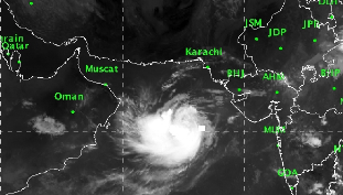
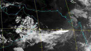
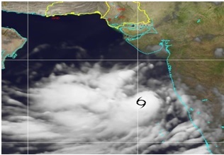
Potential Tropical Cyclone Activity in Northeast Arabian Sea The Spokesperson Tropical Cyclone Warning Center of Met Department informed that the low pressure Area over eastcentral and adjoining Northeast Arabian Sea has intensified into a Depression and lay centred around Lat: 19.8°N and long: 69.4°E, about 610 km Southeast of Karachi. It is likely to intensify further into a Tropical Cyclone during next 18/24 hrs and move westward to Oman coast. None of Pakistan coastal area is under any threat from this system. Note: - Fishermen of Sindh are advised not to venture into deep sea during the next few days.
Satellite image at 11:15 PST of 22nd Sep 2019
Spokesperson
Date: August 29, 2019 Time: 1200 PST
Weather Warning: Heavy Rain in Karachi in Next 24 hrs: (1600/Thu-1200 PST/Fri) (Impact: Risk of Urban Flooding & Water Logging) The prevailing spell of rain in Sindh is very likely to intensify in next 24 hours, producing moderate to heavy rains in Sindh particularly in Karachi, Thatta, Jamshoro, Dadu, Kambar Shahdad Kot, Nausheroferoz, Badin, Sanghar and Larkana districts during Thursday evening to Friday evening. KARACHI Due to heavy rainfall in the range of 50-70 mm (during 1600/Thu-1200 PST/Fri), the situation of urban flooding in Karachi may further be aggravated on Friday, with water logging in low lying areas of the city. Note: The concerned authorities of Sindh including Karachi are advised to take the precautionary measures accordingly. Spokesman Date: August 26, 2019 Time: 1700 PST
Press Release : Rains/thundershower predicted in Southern half of the Country from Tuesday to Thursday Met office informed that a monsoon low over Northwest Orrisa has moved West-Northwestwards and today lies over Central parts of Madhya Pradesh and likely to reach north Rajasthan on Tuesday. Under the influence of this weather system:
Rains/thundershower (with isolated heavy falls) is expected at scattered places in Mirpurkhas, Thatta, Hyderabad, Karachi, Shaheed Benazirabad divisions from Tuesday (night) to Thursday, while at isolated places in Sukkur, Larkana ,D.G Khan, Bahawalpur, Zhob, Sibbi, Kalat divisions during the period. All concerned authorities are advised to remain VIGILANT and take precautionary measures during the forecast period. Spokesman Date: August 15, 2019 Time: 1700 PST
Press Release : Weather forecast for Karachi Met office has forecasted light to moderate rainfall for Karachi during next 24-48 hours. No severe weather system is likely to affect Karachi during this time period. Pakistan Meteorological Department (PMD) denies reports on social media such as "another intense weather system will grip Karachi on Thursday and Friday".
Spokesman
Date: August 13, 2019 Time: 1300 PST
Weather Advisory : Monsoon Rains/wind-thunderstorm predicted in the Country from Tuesday (Night) to Saturday Met office informed that another monsoon low pressure has developed over northwest Bay of Bengal and its adjoining areas and likely to move westwards and reach Rajasthan (India) on Thursday. Strong monsoon currents from Bay of Bengal and Arabian sea are likely to penetrate northern parts of the country from Tuesday (evening/night) and expected to intensify from Wednesday. A strong westerly wave is also likely to interact with monsoon currents on Wednesday. Under the influence of this weather system:
Note: Heavy falls may generate flash flooding in Hazara, Malakand, Rawalpindi, Gujranwala, D.G.Khan divisions, Islamabad and Kashmir, while urban flooding in Peshawar, Rawalpindi, Gujranwala, Lahore divisions during Wednesday and Thursday. Possibility of landslide in Malakand, Hazara divisions, Gilgit Baltistan and Kashmir cannot be ruled out during the period. All concerned authorities are advised to remain ALERT and take precautionary measures during the forecast period. Spokesman
Date: August 06, 2019 Time: 1700 PST Weather Advisory 1: Monsoon Rains/wind-thunderstorm predicted in Southern half of the Country from Friday to Monday Met office informed that a well marked monsoon low pressure has formed over north Bay of Bengal and its adjoining areas, likely to move westwards and may reach over Indian Gujrat region around morning of 9th August. Under the influence of this weather system:
Widespread rains/wind-thunderstorm is expected in Mirpurkhas, Thatta, Hyderabad, Karachi, Shaheed Benazirabad divisions from Friday (evening/night) to Monday (morning).
Scattered rains/wind-thunderstorm is also expected in Zhob, Kalat, Sibbi, Naseerabad, Makran, Sukkur and Larkana divisions during the period.
Isolated moderate to heavy falls are also expected in lower Sindh (Mirpurkhas, Thatta, Hyderabad, Karachi, Shaheed Benazirabad divisions), Kalat, Zhob, Naseerabad, Sibbi divisions from Friday (night) to Sunday.
Note: Heavy falls may generate urban flooding in Karachi, Thatta and Hyderabad divisions on Friday (night) to Sunday, while flash flooding in Kalat, Sibbi, Zhob, Naseerabad divisions during the period. All concerned authorities are advised to remain ALERT and take precautionary measures during the forecast period. Weather Advisory 2: More monsoon Rains/wind-thunderstorm predicted in Northern half of the Country from Wednesday to Saturday Met office informed that a well marked monsoon low pressure has formed over North Bay of Bengal and its adjoining areas. Moderate monsoon currents from Bay of Bengal are likely to penetrate upper parts of the country on Wednesday, expected to intensify during Thursday and Friday. Under the influence of this weather system:
Widespread rains/wind-thunderstorm is expected in Rawalpindi, Gujranwala, Lahore, Sargodha, Faisalabad divisions, Islamabad and Kashmir, while at scattered places in Khyber Pakhtunkhwa from Wednesday (evening/night) to Saturday.
Isolated rains/wind-thunderstorm is also expected in Multan, D.G.Khan, Sahiwal, Bahawalpur divisions from Wednesday (evening/night) to Saturday. . Isolated moderate to heavy falls are also expected in Hazara, Rawalpindi, Gujranwala, Lahore, Faisalabad divisions, Islamabad and Kashmir on Thursday and Friday.
Note: Heavy falls may generate flash flooding in Hazara, Malakand, Rawalpindi, Gujranwala, D.G.Khan divisions and Kashmir, while urban flooding in Peshawar, Rawalpindi, Gujranwala, Lahore, Sargodha, Faisalabad divisions during Thursday and Friday. Possibility of landslide in Malakand, Hazara divisions, Gilgit Baltistan and Kashmir cannot be ruled out during the period. All concerned authorities are advised to remain ALERT and take precautionary measures during the forecast period. Spokesman
Date: July 30, 2019 Time: 1600 PST Weather Advisory: Monsoon Rains/wind-thunderstorm predicted in Upper and Central Parts of the Country from Wednesday(evening) to Friday Met office informed that monsoon currents presently active over lower parts of the country are expected to weaken during next 24 hours. However, strong monsoon currents from Arabian Sea and Bay of Bengal are likely to penetrate upper parts of the country from Wednesday (evening/night). A westerly wave is also likely to interact with monsoon currents on Thursday and Friday. Under the influence of this weather system:
Widespread rains/wind-thunderstorm (with isolated heavy to very heavy falls) are expected in Hazara, Malakand, Peshawar, Mardan, Rawalpindi, Gujranwala, Lahore, Sargodha, Faisalabad divisions, Islamabad and Kashmir from Wednesday (evening/night) to Friday.
Scattered rains/wind-thunderstorm (with isolated heavy falls) is also expected in Kohat, Bannu, D.I.Khan, Zhob, D.G.Khan, Multan and Sahiwal divisions and Gilgit Baltistan during Thursday and Friday. Note: Heavy falls may generate flash flooding in Hazara, Malakand, Rawalpindi, Gujranwala, D.G.Khan divisions and Kashmir, while urban flooding in Peshawar, Rawalpindi, Gujranwala, Lahore, Sargodha, Faisalabad divisions during Thursday and Friday. Possibility of landslide in Malakand, Hazara divisions, Gilgit Baltistan and Kashmir cannot be ruled out during the period. All concerned authorities are advised to remain ALERT and take precautionary measures during the forecast period. Spokesman
Date: July 25, 2019 Time: 1500 PST Weather Advisory: Monsoon Rains/wind-thunderstorm predicted in Sindh and Parts of Balochistan from Sunday to Tuesday Met office informed that monsoon currents presently active over upper parts of the country are expected to spread to central and southern parts of the country during next 24-48 hours. Meanwhile a Low Pressure Area is likely to develop over Indian Rajasthan on Sunday. Under the influence of this Low Pressure Area (LPA) following weather is expected:
Note: Heavy falls may generate urban flooding in Karachi, Thatta and Hyderabad divisions on Monday and Tuesday, while flash flooding in Kalat, Sibbi, Zhob divisions during the period. All concerned authorities are advised to remain ALERT and take precautionary measures during the forecast period. Spokesman
Date: July 22, 2019 Weather Advisory: Widespread Monsoon Rains/wind-thunderstorm Predicted in Upper and Central Parts of the Country from Wednesday to Saturday · Met Office informed that weak monsoon currents from Arabian Sea are continuously penetrating in upper and central parts of the country. However, strong monsoon currents from Arabian Sea and Bay of Bengal are likely to enter in upper parts of the country from Wednesday (evening/night) and likely to spread central and southern parts from Thursday to Saturday. Under the influence of this following weather is expected: · Widespread rains/wind-thunderstorm (isolated heavy to very heavy falls) are expected in Rawalpindi, Sargodha, Gujranwala, Lahore, Faisalabad, Hazara, Malakand, Peshawar, Mardan divisions, Islamabad and Kashmir from Wednesday (evening/night) to Saturday. · Scattered rains/wind-thunderstorm (isolated moderate to heavy falls) are also expected in Kohat, Bannu, D.I Khan, Zhob, Kalat, Sibbi, Naseerabad, D.G Khan, Multan, Sahiwal, Bahawalpur divisions and Gilgit Baltistan during the period. · HIGH to very HIGH Flood with sharp peaks of Exceptional HIGH Flood are expected Upstream of Mangla. HIGH to Very HIGH Flood is also likely in River Chenab at Marala and its downstream. Flows May attain Medium to High Flood level in Rivers Indus at Tarbela and Kabul at Nowshera along with their tributaries during Thursday to Saturday. Note: Heavy falls may generate flash flooding in local nullah/riverine of Hazara, Rawalpindi, Gujranwala divisions and Kashmir and may trigger landslides in Hazara division and Kashmir on Thursday and Friday, while in Zhob, Kalat and D.G.Khan divisions on Friday and Saturday. Heavy falls may also generate urban flooding in Lahore, Gujranwala, Faisalabad, Rawalpindi, Peshawar and Sargodha divisions during the period. All concerned authorities are advised to remain ALERT and take precautionary measures during the forecast period.
Spokesman
Date: July 18, 2019 Press Release Monsoon Activity likely to Persist in Upper / Central parts of the Country till Monday Met Office informed that moderate monsoon currents from Arabian Sea are still penetrating in upper and central parts of the country and likely to continue till Monday. Under the influence of this weather system, more wind-thunderstorm/rains (isolated moderate to heavy falls) are expected at scattered places in Kashmir, Islamabad, Hazara, Rawalpindi, Gujranwala, Lahore, Sargodha, Sahiwal, Faisalabad divisions, while at isolated places in Malakand, Peshawar, Mardan, Kohat, Bannu, Zhob, Bahawalpur, D.G. Khan and Sukkur divisions during the period. Note: Possibility of landslides in Hazara division and Kashmir cannot be ruled out during the period due to persistent rains. All concerned authorities are advised to remain vigilant during the forecast period.
Spokesman
Date: July 11, 2019 Weather Advisory More Monsoon Rains Thundershowers Predicted in Northern Half of the Country from Friday to Thursday Met Office informed that moderate monsoon currents from Arabian Sea are continuously penetrating in northeastern parts and likely to strengthen in upper parts of the country from Friday evening/night. Westerly wave is also expected to enter upper parts of the country on Sunday. Due to this following weather is expected:
Note: Heavy falls may generate flash flooding in local nullah/riverine of Hazara, Gujranwala, D.G.Khan divisions and Kashmir and may trigger landslides in Hazara division and Kashmir. Possibility of urban flooding in Lahore, Gujranwala, Faisalabad, Rawalpindi divisions cannot be ruled out during the period. All concerned authorities are advised to remain ALERT and take precautionary measures during the forecast period.
Spokesman
Date: July 03, 2019 Press Release Rain/Dust-thundershower Predicted in upper and central parts of the country during next couple of days Met Office informed that weak to moderate monsoon currents are penetrating north eastern parts of the country, and likely to strengthen during the forthcoming days. Under the influence of this weather system:
Spokesman Date: June 21, 2019 Time: 1500 PST Press Release Installation of Weather Surveillance Radar at Sukkur A signing ceremony on the Minutes of Discussions on the project “Installation of Weather Surveillance Radar at Sukkur in the Islamic Republic of Pakistan” was held in Pakistan Meteorological Department, today at 11.00 am on 21-06-2019. The ceremony was attended, besides JICA Expert Team, by officials from NDMA, FFC. The project would be funded by Government of Japan through grant.
It worth to mention that Government of Japan is assisting Pakistan Meteorological Department through provision of grant-in-aid for the last three decades. Some of the projects currently in progress are:
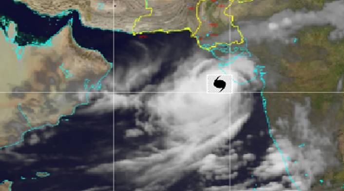
These projects after completion would ultimately strengthen the capabilities of Pakistan Meteorological Department in issuing Early Warning on Floods. Spokesman Date: June 17, 2019 Time: 2100 PST Final alert Depression over Northeast Arabian Sea The Tropical Cyclon “VAYU” having moved northeastwards, weakened into a depression and now lies over Northeast Arabian Sea (near Indian Gujarat coast). The system is likely to cross the Gujarat coast late tonight/early morning of 18 June The sea conditions are still rough/very rough over Northeast Arabian Sea, the fisherman are therefore advised not to venture into deep sea till evening of 18 June. This is the last alert issued for this system
Fig. Satellite imagery at 2100 PST, 17th June 2019
Date: June 17, 2019 Time: 1100 PST Tropical Cyclone Alert-9
Severe Cyclonic Storm “VAYU” in the Arabian Sea The severe Cyclonic Storm (SCS)“VAYU” in the East Arabian Sea has weakened into a Cyclonic Storm and now lies centred around Lat.22.8°N and Long.66.8°E at 0800 PST of 17 June 2019 at 330 km South of Karachi. The maximum sustained surface winds are 65-80 km/hour gusting to 90 km/hour around the system centre. TC VAYU is likely to further weaken into a depression by evening/night today. Under the influence of this system, isolated Dust/Thunderstorm-light showers are expected in coastal region of Thatta district. The fishermen of Sindh are advised not to venture in open sea till tomorrow, as the sea conditions are likely to continue to be rough.
Fig. Satellite imagery at 0800 PST, 17th June 2019 Date: June 16, 2019 Time: 1100 PST Tropical Cyclone Alert-8 Severe Cyclonic Storm “VAYU” in the Arabian Sea Very Severe Cyclonic Storm (VSCS)“VAYU” in the East Arabian Sea has moved in northwest direction during last six hours and weakened into a Severe Tropical Storm. VAYU now lies centered around Lat.21.2°N and Long.65.5°E at 0800 PST of 16 June 2019 at 440 km South/southwest of Karachi. The maximum sustained surface winds are 100-110km/hour gusting to 125km/hour around the system centre. TC VAYU is likely to recurve towards northeast and further weaken into a Cyclonic Storm by mid night today. Under the influence of this system, isolated Dust/Thunderstorm-light showers are expected in coastal region of Thatta district. The sea breeze is likely to resume today evening and heatwave condition likely to ease out. The fishermen of Sindh are advised not to venture in open sea till Monday evening/night, as the sea conditions are likely to be very rough/high. Note: All concerned authorities of Sindh province are requested to remain alert and take precautionary measures during coming days regarding the impact of TC VAYU.
Fig. Satellite imagery at 0900 PST, 16th June 2019 Date: June 15, 2019 Time: 1100 PST Tropical Cyclone Alert-7 Very Severe Cyclonic Storm “VAYU” in the Arabian Sea Very Severe Cyclonic Storm (VSCS)“VAYU” in the East Arabian Sea remained practically stationary with slight westward drift during last 6 hours, now lay centered around Lat.20.7°N and Long.67.4°Eat 0800 PST of 15 June 2019 at a distance of about 475 km South of Karachi. The maximum sustained surface winds are 120-130 km/hour gusting to 145 km/hour around the system centre. TC VAYU is likely to move in westerly direction during next 18-24 hours and then recurve towards northeast and start weakening. Under the influence of this system, few Dust/Thunder-showers are expected in Thatta district. The sea breeze is likely to remain cut-off today and heat wave to persist in Lower Sindh including Karachi. The fishermen of Sindh are advised not to venture in open sea till Sunday/Monday morning, as the sea conditions are likely to be very rough/high. Note: All concerned authorities of Sindh province are requested to remain alert and take precautionary measures during coming days regarding the impact of TC VAYU.
Fig. Satellite imagery at 0900 PST, 15th June 2019 Date: June 14, 2019 Time: 1100 PST Tropical Cyclone Alert-6 Very Severe Cyclonic Storm “VAYU” in the Arabian Sea
Very Severe Cyclonic Storm (VSCS) “VAYU” in the East Arabian Sea has moved further northwestward during last 12 hours, now lay centered around Lat. 21.0°N and Long. 68.5°E at 0800 PST of 14 June 2019 at a distance of about 410 km South of Karachi. The maximum sustained surface winds are 135-145 km/hour gusting to 160 km/hour around the system centre. TC VAYU is likely to move in North-westerly direction for some time and then remain practically stationary. Under the influence of this system, few Dust/Thunder-showers are expected in southeast Sindh (Thatta and Badin districts) today. The seabreeze is likely to remain cut-off on 14-15 June and heatwave conditions will prevail in Lower Sindh including Karachi. The fishermen of Sindh are advised not to venture in open sea till Sunday evening, as the sea conditions are likely to be very rough/high. Note: All concerned authorities of Sindh province are requested to remain alert and take precautionary measures during coming days regarding the impact of TC VAYU.
Fig. Satellite imagery at 0800 PST, 14th June 2019 Date: June 13, 2019 Tropical Cyclone Alert-5 Time: 1100 PST
Very Severe Cyclonic Storm “VAYU” in the Arabian Sea
Very Severe Cyclonic Storm (VSCS) “VAYU” in the East Arabian Sea has moved further north-northwestward during last 6 hours, now lay centered around Lat.20.4.N and Long.69.5E at 0800 PST of 13 June 2019 at a distance of about 540 km Southeast of Karachi. The maximum sustained surface winds are 150-160 km/hour gusting to 175 km/hour around the system centre. TC VAYU is likely to continue to move in northwesterly direction. Under the influence of this system, scattered Dust/Thunder-showers are expected in southeast Sindh (Thatta, Badin and Tharparkar districts) on Thursday-Friday. While isolated Dust-thundershowers may occur in rest of Sindh during the period. The seabreeze is likely to remain cut-off on 13-15 June and heatwave conditions will prevail in coastal areas of Sindh including Karachi. The fishermen of Sindh are advised not to venture in open sea during Wednesday evening to Friday evening, as the sea conditions are likely to be very rough/high. Note: All concerned authorities of Sindh province are requested to remain alert and take precautionary measures during coming days regarding the impact of TC VAYU. .
Fig. Satellite imagery at 0900 PST, 13th June 2019 Date: June 12, 2019 Tropical Cyclone Alert-4 Time: 1100 PST Very Severe Cyclonic Storm “VAYU” in the Arabian Sea Tropical Cyclone “VAYU” in the East Arabian Sea has intensified as Very Severe Cyclonic Storm (VSCS) and moved further north-northwestward during last 6 hours, now lay centered around Lat.18.N and Long.70.0E at 0800PST of 12 June 2019 at a distance of about 725 km southeast of Karachi. The maximum sustained surface winds are 135-145 km/hour gusting to 160 km/hour around the system centre. TC VAYU is likely to continue to move in northerly direction. Under the influence of this system, widespread Dust/Thunder-showers with scattered heavy to very heavy falls are expected in southeast Sindh (Thatta, Badin and Tharparkar districts) on Thursday and Friday. While scattered/isolated Dust-thundershowers may occur in rest of Sindh during the period. The seabreeze is likely to remain cutoff on Thursday-Friday (13-14 June) which can lead to heatwave like conditions in coastal areas of Sindh including Karachi. The fishermen of Sindh are advised not to venture in open sea during Wednesday evening to Friday evening, as the sea conditions are likely to be very rough/high. Note: All concerned authorities of Sindh province are requested to remain alert and take precautionary measures during coming days regarding the impact of TC VAYU.
Fig. Satellite imagery at 0700 PST, 12th June 2019 Date: June 11, 2019 Cyclone Alert-3 Time: 2000 PST Tropical Cyclone “VAYU” in the Arabian Sea Tropical Cyclone “VAYU” in the East Arabian Sea has moved further northward during last 8 hours and slightly intensified now laying centred around Lat.16.5N and Long.70.8E at 2000PST of 11 June 2019 at a distance of about 1000 km south of Karachi. The maximum sustained surface winds are 80-90km/hour gusting to 110 km/hour around the system centre. TC VAYU is likely to intensify further into a Very Severe Tropical Cyclone during next 12-18 hours and continue to move in northerly direction. Under the influence of this system, widespread Dust/Thunder-showers with isolated heavy falls are expected in southeast Sindh (Thatta, Badin and Tharparker districts) on Thursday/Friday. While scattered/isolated Dust-thundershowers may occur in rest of Sindh during the period. The seabreeze is likely to remain cutoff on Thursday/Friday which can lead to heatwave like conditions in coastal areas of Sindh including Karachi. The fishermen of Sindh are advised not to venture in open sea during Wednesday evening to Friday evening, as the sea conditions are likely to be very rough/high. Note: All concerned authorities of Sindh province are requested to remain alert during coming days regarding the impact of TC VAYU.
Fig. Satellite imagery at 0900 PST, 11th June 2019 Date: June 11, 2019 Cyclone Alert-2 Time: 1100 PST Tropical Cyclone “VAYU” in the Arabian Sea Yesterday’s deep depression in the East Arabian Sea having moved North/Northwest-ward intensified into a Tropical Cyclone “VAYU” and lay centred around Lat.14.7N and Long.70.6E at 0800PST of 11 June 2019. The Tropical Cyclone “VAYU” currently locates at a distance of about 1150 km south of Karachi. The maximum sustained surface winds are 70-80km/hour gusting to 90 km/hour around the system centre. The system is likely to intensify further into a Severe Tropical Cyclone by evening today and will continue to move in northerly direction during next 24 hours. Under the influence of this system, widespread Dust/Thunder-showers with isolated heavy falls are expected in southeast Sindh (Thatta, Badin and Tharparker districts) on Thursday/Friday. While scattered/isolated Dust-thundershowers may occur in rest of Sindh during the period. The seabreeze is likely to remain cutoff on Thursday/Friday which can lead to heatwave like conditions in coastal areas of Sindh including Karachi. The fishermen of Sindh are advised not to venture in open sea during Wednesday evening to Friday evening, as the sea conditions are likely to be rough/very rough. Note: All concerned authorities of Sindh province are requested to remain alert during coming days regarding the impact of TC VAYU.
Fig. Satellite imagery at 0900 PST, 11th June 2019 Date: June 10, 2019 Time: 1100 PST Cyclone Alert Potential Cyclonic Activity in the Arabian Sea The Tropical Cyclone Warning Centre of PMD informed that the well-marked low-pressure area in the East Arabian Sea has strengthened into a depression and lay centred around Latitude 11.7N and Longitude 71.0E, at a distance of about 1500 km south of Karachi. The system is likely to move initially North/Northwest-ward and strengthen further into a Tropical Cyclone during next 36 hours. Currently none of Pakistan coastal area is under threat from this system. However, the fishermen of Sindh are advised to remain alert and not to venture in deep sea. The authorities and stakeholders are requested to abreast them of system updates through PMD website.
Fig. Satellite imagery at 0900 PST of today the 10th June 2019 Spokesman Date: May 13, 2019 Time: 1500 PST Press Release More dust-thunderstorm/rain predicted in the country during current week Met Office informed that a shallow westerly wave is affecting upper and central parts of the country and likely to intensify on Wednesday. Under the influence of this weather system dust-thunderstorm/rain is expected at scattered places in Khyber Pakhtunkhwa, Punjab, Islamabad, Balochistan, Upper Sindh, Gilgit Baltistan and Kashmir from Wednesday to Saturday. Isolated heavy fall is also expected in Makran, Kalat, Zhob and D.G Khan divisions on Wednesday/Thursday. Cloudy weather with few chances of dust-thunderstorm with light rain also expected along Sindh-Makran coast including Karachi during Thursday and Friday. Due to this weather system, day temperatures likely to remain (4-6)°C below normal in different parts of the country during the period.
Spokesman
Date: April 20, 2019 Press Release Dust-Thunderstorm/rain predicted in Upper & Central parts of the country from Tuesday to Thursday Met Office informed that westerly wave is likely to enter western parts on Tuesday and may affect upper and central parts till Thursday and persist over northern areas till Friday. Under the influence of this weather system:
Note: Farmers are advised to take precautionary measures during the forecast period. Spokesman
Date: April 12, 2019 Press Release Dust-thunderstorm/rain predicted in the country from Saturday to Wednesday Met Office informed that a shallow westerly wave is presently affecting upper and central parts of the country. This weather system is likely to intensify on Sunday (evening/night) and grip most parts of the country on Monday. Under the influence of this weather system:
Note: Heavy falls may generate flash flooding in local nullah/riverine in Makran, Quetta, Zhob, D.G khan divisions on Monday/Tuesday. Heavy rains may trigger landslides in Malakand, Hazara divisions, Gilgit Baltistan and Kashmir on Tuesday and Wednesday. Farmers are advised to take precautionary measures during the forecast period. All concerned authorities are advised to remain ALERT. Spokesman
Date: March 08, 2019 Press Release More Rain/Snow predicted in the country from Saturday (night) to Monday Met Office informed that a westerly wave is likely to enter Balochistan on Saturday (night) and likely to grip parts of the country on Sunday. Under the influence of this weather system:
Note: Heavy falls may generate flash flooding in local nullah/riverine in Quetta, Zhob, Sibbi and Kalat divisions on Sunday and may trigger landslides in Malakand, Hazara divisions, Gilgit Baltistan and Kashmir on Monday. All concerned authorities are advised to remain ALERT and take precautionary measures during the period. Spokesman
Date: February 27, 2019 Weather Warning: Rain thunderstorm associated with windstorm in Balochistan, Sindh & Southern Punjab Met office warned that according to the latest weather analysis rain thunderstorm (with heavy falls) accompanied by windstorm (gusting 80-120 km/h) as predicted on 26th February, 2019 may create untoward situation in parts of Balochistan on Friday (night) to Saturday while in Sindh including Karachi and Southern Punjab (D.G.Khan, Multan and Bahawalpur divisions) on Saturday. Note: All concerned authorities and general public are advised to take precautionary measures during the period.
Spokesman
Date: February 26, 2019 Weather Advisory: More widespread rains predicted in the country from Friday to Monday (morning) Met office informed that a strong rain bearing system is likely to approach Balochistan on Thursday (night) and likely to grip southern parts of the country on Friday and may persist in upper parts till Monday (morning). Under the influence of this weather system: · Widespread rain-thunderstorm (with isolated heavy falls) associated with windstorm is expected in Balochistan from Thursday (night) to Sunday (Morning), while at scattered places in Sindh on Friday and Saturday. · Widespread rain-thunderstorm (with few moderate to isolated heavy falls & snowfall over the hills) with strong gusty winds also expected in Khyber Pakhtunkhwa, Punjab, Islamabad, Gilgit Baltistan and Kashmir from Friday (night) to Monday (morning). Note: Heavy falls may cause flash flooding in local nullah/riverine of Balochistan and hill torrents of DG Khan from Friday (evening/night) to Saturday and trigger landslides in Malakand, Hazara, Gilgit Baltistan and Kashmir during Saturday and Sunday. All concerned authorities are advised to remain ALERT during the period.
Spokesman
Date: February 15, 2019 Press Release More Rain/Snow predicted in the country during the coming week Met office informed that a strong rain bearing system is likely to enter in the country on Sunday (evening/night) and is likely to persist till Friday.
Note: Heavy falls may trigger landslides in Malakand, Hazara, Gilgit Baltistan and Kashmir and may cause flash flooding in local nullah/riverine of Balochistan and hill torrents of DG Khan on Wednesday and Thursday.
Spokesman
Date: February 03, 2019 Press Release
Rain/Snow predicted in the country from Monday to Wednesday Met Office informed that a westerly wave is likely to enter western parts of the country on Monday, likely to grip different parts on Tuesday and may persist till Wednesday. Under the influence of this weather system:
Spokesman
Date: January 28, 2019 Press Release Rain/Snow predicted in the country during mid of the week Met Office informed that westerly wave is likely to enter western parts of the country on Tuesday (evening/night), likely to grip different parts on Wednesday and may persist in upper parts till Thursday. Under the influence of this weather system:
Note: Moderate to heavyfalls can trigger landslides in Malakand, Hazara divisions, Gilgit-Baltistan and Kashmir during Wednesday to Thursday. Spokesman
Date: January 18, 2019 Press Release Rain/Snow predicted in the country from the weekend Met Office informed that a fresh westerly wave is likely to enter western parts of the country on Saturday and likely to grip most parts on Sunday. Under the influence of this weather system:
Note: Moderate to heavy rain with snowfall can trigger landslides/avalanches in Malakand, Hazara division, Gilgit-Baltistan and Kashmir from Monday to Wednesday. All concerned authorities are advised to remain ALERT during the period. Spokesman
Date: January 08, 2019 Press Release Rain/Snow predicted in parts of the country during second half of week Met Office informed that a fresh westerly wave is likely to enter western parts of the country on Thursday (evening/night) and likely to grip different parts from Friday. Under the influence of this weather system: · Rain with snowfall over the hills is expected at scattered places in Quetta, Zhob, Bannu, Kohat, D.I.Khan on Thursday (evening/night) and Friday, while Malakand, Hazara, Peshawar, Mardan, Sargodha, Gujranwala, Faisalabad, Rawalpindi, Lahore divisions, Islamabad, Gilgit-Baltistan and Kashmir from Thursday evening/night to Saturday. Snowfall over hills is also expected in Malakand division (Swat, Chitral, Kalam, Malamjabba & upper Dir), Hazara division Murree and Galliyat, Kashmir and Gilgit-Baltistan during the period. · Rain is expected at isolated places in D.G.Khan, Multan, Bahawalpur, Sahiwal and Sukkur divisions on Friday/Saturday. Light rain is also expected along Sindh-Makran coast including Karachi during the period. · Foggy conditions in plain areas of Punjab and upper Sindh are likely to subside during the period. Spokesman |
||||
|
|
|
|||